GeObservatory is activated in major geohazard events (earthquakes, volcanic activity, landslides,etc.) and automatically produces a series of Sentinel-1 based co-event interferograms (DInSAR) to map the surface deformation associated with the event. It also produces pre-event interferograms to be used as a benchmark.
GeObservatory can be activated in two ways:
After the system is triggered, the application automatically scans different Copernicus hubs, including the Greek Collaborative Ground Segment, to find the appropriate Sentinel-1 satellite data for interferometry.
The engine for creating the interferograms is sarscape commercial software, which processes all three Sentinel-1 subswaths.
The administrator is notified about the progress and the status of processing steps automatically by email or by consulting information tables of the service metadata database.
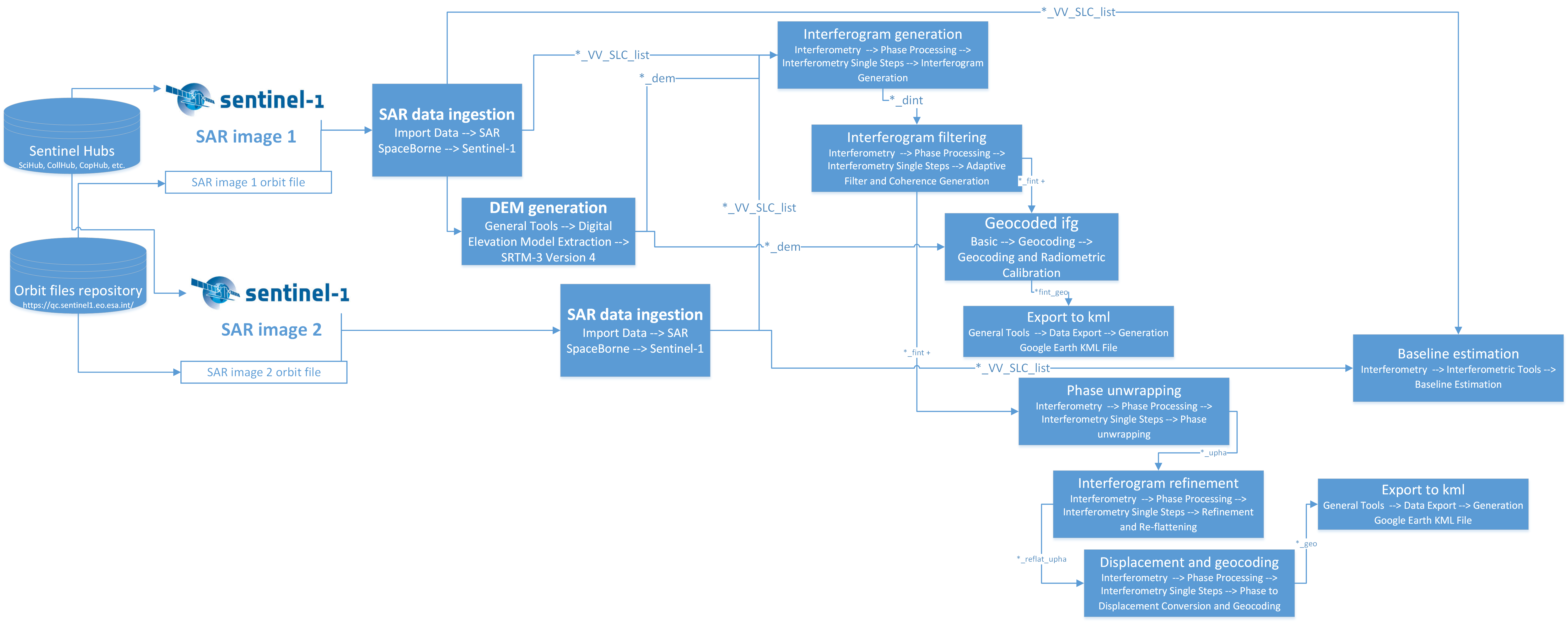
Interferometric processing chain in geObservatory
In the back-end of GeObservatory lays an application server which orchestrates the enter service. Its main components are:
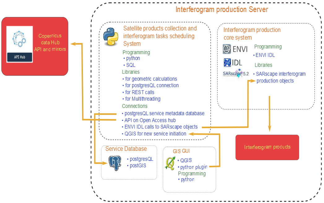
Technologies and Architecture of geObservatory
All Sentinel-1A and Sentinel 1-B used in this applications are collected and ingested through the Hellenic National Sentinel Data Mirror Site (HNSDMS), a web-based system designed to provide EO data users with Search-Cataloguing-Sorting and Dissemination capabilities for the Sentinel products.
HNSDMS is operated by the National Observatory of Athens (NOA), while the hosting infrastructure is the Greek Research and Technology Network, which is powered by GEANT e-infrastructure, for reliable and fast network links, and unconstrained access to computing, analysis and storage, applications.
The current version of HNSDMS comprises the 2nd generation of the Mirror Site built upon the legacy of the 1st operational prototype version developed under the current EU-ESA GMES / NOA agreement. HNSDMS runs a customized version of the Data Hub Software (DHuS), which provides a simple web interface to allow interactive data discovery and download, and a powerful Application Programming Interface (API) that allows users to access the data via computer programs and scripts thereby automating/integrating the download within their workflow.
The SENTINEL collaborative ground segment initiative of the European Space Agency is intended to allow complementary access to SENTINEL data and/or to specific data products or distribution channels. It is composed of elements funded by third parties (i.e. from outside the ESA/EU Copernicus programme) and provides the framework for international cooperation.
GeObservatory is a beta version application which is supported by the BEYOND team on a best effort basis. The interferometric products are generated on a fully automatic approach, without an intervention of an expert. The team is not responsible for the use of these products by third parties.
GeObservatory has been conceived and developed by the Geohazards remote sensing team of BEYOND Center of Excellence.
For any information concerning GeObservatory functionality, its processing engine, suggestions and feedback please contact Ioannis Papoutsis
Location | Magnitude | Depth | Date/Time |
---|
Latest Event | |
Recent Events (Last 5) | |
Historic Events | |
View | Type | Reference | Secondary | Orbit | Mode | Opacity | Download |
---|